Atmosphere
 Atmos. turbulences
 Ocean and climate
 Natural Factors
 Climatic and oceanic phenomenas
 Photos, videos
 Diverse
 Simulations...
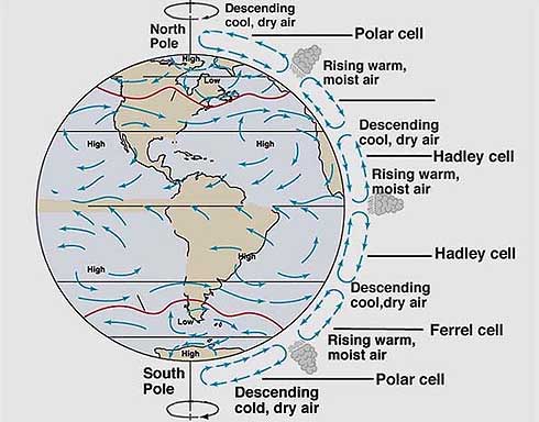
The worldwide system of winds which transports warm air from the equator, where sunlight is most important, to the higher latitudes is called the general circulation of the atmosphere, causing climate zones of the Earth. The general circulation of air is broken into three cells
in each hemisphere :
Video of global atmospheric circulation Sunlight is strongest near the equator. The heated air rises at this point and extends north and south. After the air which is cooled as is heavier, it fulls down back to the Earth's surface in the subtropical climate zone between latitudes 25° and 40°. This cool air descending stabilizes the atmosphere, preventing clouds formation and precipitation. Consequently, several climates of the desert in the world can be found in the subtropical climate zone. Surface air from subtropical regions returns to Ecuador to replace the rising air, thus completing the cycle of air circulation in the Hadley cell. Although the physical reality of Hadley cells has been questioned, they provide an excellent way to describe how heat is transfered through the Earth by air movement. The general circulation is in use to transfer thermal energy from warm equatorial regions to temperate and colder polar regions. Without such latitudinal redistribution of heat, Ecuador would be much hotter and the poles would be much colder. Without rotation of the Earth, the air would travel from
north to south directly through the difference of temperature
between the low and high latitudes. The effect of the Coriolis
force due to the rotation of the Earth, however, swings
the winds to their right in the Northern Hemisphere, and to
their left in the Southern Hemisphere. So the movement of
the air towards the Equator, a flow of Northeast in the southern
hemisphere and Southeast in the Northern hemisphere create
the trade winds in the tropical
regions. The air that travels toward the poles constitute
he westerlies associated with the belt of cyclonic systems
of low pressure at about 50° to 60° north and south.
In general, where the air goes down, high pressures develop,
for example at subtropical latitudes or near the poles. Where
air rises, air pressure is low, as in Ecuador and in the middle
latitudes where thunderstorms
or frontal systems develop.
The Intertropical
Convergence Zone (ITCZ) moves with the inclination
of the axis of
|
.gif)