 Atmosphere
 Atmos. turbulences
 Ocean and climate
 Natural Factors
 Climatic and oceanic phenomenas
 Photos, videos
 Diverse
 Simulations...
1st
PART
DESCRIPTION OF CYCLONES A cyclone is an atmospheric perturbation in the aspect of a large cloud mass spiral bands, associated with a very intense depression with swirling winds more than 74.mph (120.km/h). In the southern hemisphere, the winds rotate in the direction of clockwise in the cyclone. And the direction of rotation is opposite in the northern hemisphere. The direction of rotation of the wind around the depression is due to the rotation of the Earth called CORIOLIS force .
Warm, moist air rises high altitude turning
around the
A video giving information on cyclones TYPES
AND CONDITONS OF FORMATION CYCLONES there are several types and main mechanisms of formations of cyclones :
Tropical cyclones form over warm
water in tropical seas and draw their energy from
the latent heat of condensation of water.
To develop a tropical cyclone favourable conditions are necessary : a depression must cross over ocean heated more than 78,8°F (26°C) at least 60 meters depth and distant for more than 550 km from equator. This is from 5° latitude that the Coriolis force can act on the trigger initial vortex as it is null at the equator. The force generated by the earth's rotation causes wind deflection to the east in the northern hemisphere. This allows warm moist air to rise to 9.000 m. Then the atmospheric pressure decreases. With the Coriolis force, the hot and humid air begins to swirl. Water vapor forms clounds. Gerater is the difference between the air temperature low and high altitude, the more air is unstable, creating violent thunderstorms. Spiral, cold air descends and it warms and rises again. When a tropical cyclone reaches land or in cold water the winds weaken as it is no longer powered by the vapor of warm water.
A depression passes over an area of
water to more than
Extra-tropical cyclones (winter storms) occur in the middle latitudes of the Earth and draw their energy from areas with heavy difference of temperatures between the tropics and the poles. The majority of their power is due to baroclinic processes. Their field of temperature and humidity is asymmetric. EPSILON, VINCE, DELTA of 2005 are called extra-tropical cyclones according to the season and thus as the temperature of the ocean was lower at 78,8°F (26°C). Différences entre les cyclones extra-tropicaux et les cyclones tropicaux
Subtropical cyclone are cyclones which both the characteristics of tropical and extratropical cyclones. Their characteristics of tropical cyclones is that they can have a warm heart. But some have a cold heart. The strong winds in subtropical cyclones is wider and far from the nucleus. These cyclones can have a radius of maximum diameter 420.km. Sometimes these subtropical systems are transformed into storms or tropical cyclones as was the case with Hurricane Florence in November 1994 in the Atlantic. They are formed at subtropical latitudes so beyond the tropics, up to a latitude of 50°.
LOCATION AND DIRECTIONS CYCLONES Cyclones can move thousands of kilometres at an average speed of 12 to 15 mph (20 to 25 km/h). This speed is quite low in the phase of genesis, but it gradually increases that they stray tropical waters and head to the North (for the northern hemisphere). Then their displacement can be faster (700 to 1000 km per day).
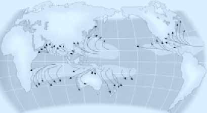
This map shows the areas where
hurricanes hit more often and Click
here to see the track of tropical cyclone activity In the northern Indian Ocean is from January to March they develop. In the North Atlantic and North Pacific, it is between June and September that tropical cyclones form. In the South Pacific and the South of the Indian ocean is from May to June and from October to December that they form. However, in the South Atlantic there is logically
not tropical cyclones that form as water is not warm
enough, and then because of the permanent presence
of a strong vertical wind shear in the troposphere
and the intertropical convergence zone which disrupts
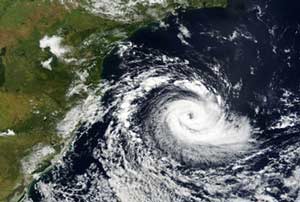
cyclone formation. But the 03/28/2004 a tropical cyclone was observed
for the first time in the South Atlantic and hit the
coast of southeastern Brazil with winds up to 93 mph
(150 km/h) and an average of 74 mph (120 km/h). This
cyclone known as Catarina was born as an extratropical
stage then is passed to the hybrid stage (warm air
at the centre in lower layers, cold air aloft) and
became a tropical cyclone at warm core (warm air at
the centre at all levels) where there is exchange
of energy between ocean-atmosphere.
Cyclone Catarina has hit Brazil, this is a rare occurence
|


