1st
PART
DESCRIPTION
OF THUNDERSTORM
Thunderstorms are among the most impressive
natural spectacles. These are violent atmospheric disturbances,
accompanied by lightning tearing the sky followed by thunderclap
amid gust of rain showers see hail.
CREATION
OF THUNDERSTORM
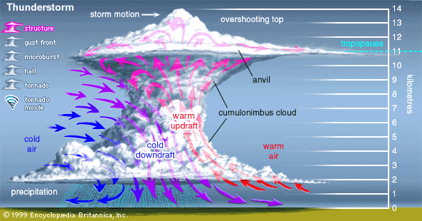
When the air is unstable in cumulus,
an updraft predominates throughout the cell and will form
a cumulonimbus. A thunderstorm
will occur. These phenomena that are in these clouds 5 to
20 km in height and about 5 km wide. There
are updrafts of warm air from over 100 km/h and downdrafts
of cold air (convective cell). At the Summit the temperature
is very low as the tropopause is lower than 32°F (0°C).
There's a big difference of temperature between the top and
the bottom of the cumulonimbus. When the cloud has reached
the maximum altitude a violent downdraft is formed causing
rainfall or hail from the top of the cloud flattened and frozen
(incus). The downdraft
of cold air eventually crush the updraft of warm air feeding
the cloud.
A video explaining the development of thunderstorms
part
2/5 : (Floods, Lightning)
Part
3/5 : (Tornadoes)
Part
4/5: (Microbursts and W)
Part
5/5: (On the Drawing Bo)
Updraft and downdraft in cumulonimbus
Click
here to see an animation of the formation of a thunderstorm
(cumulonimbus)
Thunderstorms can be formed : convective
cells of 10 km maximum at different stages of their existence
called Multicellular thunderstorm or a convective single cell
very large (from 20 to 50 km), very intense and very long
life named supercell thunderstorm. The latter are formed by
cold fronts.
The actual structure of the thunderstorm clouds
.gif)
TYPES
OF THUNDERSTORMS

The supercell thunderstorm is formed especially
in the summer and is more violent than the multicellar
thunderstorm with strong gust winds, important rainfall
or hail and lightnings often occur...
|

The multicellular thunderstorm is the coexistence
of several cumulonimbus following. These thunderstorm
can have a shelf life of one day, and can scan an
entire region.
|
Thunderstorms
are classified according to their origins :
-
FRONTAL
THUNDERSTORMS
In this category we have thunderstorms cold
front, warm front, occluded
front and prefrontal thunderstorms.
- Warm
front thunderstorm is created when an warm air
mass is unstable ahead towards a mass of cold air and rises
as cold air is denser than warm air. Rainfall wall can be
250 to 300 km length, but the width is no more than 50 km.
- Cold
front thunderstorm is often violent and likely
to cause the formation of tornadoes.
It is formed when a mass of cold air faster than the warm
front passes under it. So warm, moist air lighter than cold
air, rises creating updrafts and therefore a cumulonimbus.
- Occluded
front thundestorm occurs when a warm air mass
ousted by the meeting of two cold air masses that lifts
it. During these thunderstorms the base of cumulonimbus
is generally at very high altitudes.
- Prefrontal thunderstorm
is more difficult to predict and very violent. Three
factors involved in the formation of this thunderstorm :
a push of a cold front, unstable air and warming of the
soil consecutive of the strong radiation.
-
OROGRAPHIC THUNDERSTORMS
- Orographic thunderstorms occur by an unstable flow
of warm and moist air raised by a mountain range. Then along
the mountain these storms line up and act as the air flow
feeds them . They often erupt on the reliefs and remain
in the same place. These thunderstorms often occur in the
Pyrenees and the Alps in France, mountains near Baja California
North – specifically La Bocana to Laguna Hanson, mountains
of New Zealand etc.
-
THERMAL OR HEAT THUNDERSTORMS
-
These thunderstorms are caused by overheating
of the soil. It is in the tropics where they are very
intense as the heat on the ground reached its maximum
! These thunderstorms can burst at any time of the day
or the night also, and on land or at sea, unlike other
thunderstorms. It is of course in warm weather these thunderstorms
burst. They can repeat itself several days later.
 Atmosphere
 Atmos. turbulences
 Ocean and climate
 Natural Factors
 Climatic and oceanic phenomenas
 Photos, videos
 Diverse
 Simulations...
 ........


