 Atmosphere
 Atmos. turbulences
 Ocean and climate
 Natural Factors
 Climatic and oceanic phenomenas
 Photos, videos
 Diverse
 Simulations...
PRECIPITATIONS TYPES OF PRECIPITATIONS All forms of water falling from the sky on the Earth's surface are called precipitation. Two types of precipitation exist : - The stratiform precipitations are of low intensity but that last long because they cover a large area. They occur in depression and in the hollows which are associated with types stratus clouds. - The convective precipitation which are intensive and can be accompanied by thunderstorm or hail but they do not last long. They occur by the convective instability of the air that is associated with cumulus or cumulonimbus clouds. The precipitation can fall in three forms depending on the temperature of the air :
The unit of measurement of precipitation
is millimeters (mm). HOW DO PRECIPITATIONS FORM ? - Rain and drizzle are formed within clouds when water vapour condenses and creates droplets of 0,002 to 0,02 mm. When they will reach a size of 0,10 mm to 1 mm as they will meet with updrafts drops will be trained and there will be precipitation. The drops of drizzle are small, between 100 to 400 µm in diameter (1.µm.=.0,001.mm). They fall only very low clouds. Raindrops are 0,50.mm to about 3.mm. The drops will be even larger than the updrafts are strong. - Rain and freezing drizzle formed as rain and drizzle but after the fall of the droplets before they reach the ground in liquid form and as soon as they arrive on a floor or an object where the temperature is below 32°F (0°C) they freeze on contact. Freezing, the rain forms transparent and brittle freeze. - Snow forms when the air is quite humid and the temperature is very low (below 5°F (-15°C)) in clouds where there is the presence of of tiny corpuscles fluttering in the air (sand, smoke, ash ,...). Gradually, as the crystals fall along the cloud, the temperature must be below 32°F (0°C) so that they do not melt and stick together to the ground forming all around them the frozen branches called flakes. Greater is the distance between the birth of the snowflake and the soil, more there are chances that the snowflake becomes large. It takes thousands of ice crystals to have a single snowflake. Temperature and humidity are vary the form of the flakes. Small flakes are formed at colder temperatures as the air is not wet enough to they grow.
Between 21,2°F (-6°C) and 14°F
(-10°C) the growth of crystals is
At 10,4°F (-12°C) the growth
of crystals occurs in the plane
Between 8,6°F (-13°C) and -0,4°F
(-18°C) the growth of crystals occurs in source : Kenneth Libbrecht/Caltech.
Irregular particle (left), Button Cufflinks (middle) and ice pellets (right) - Hail is formed in cumulonimbus clouds located between 1.000 km and 10.000 km altitude where the temperature is very low, down to -40°F (-40°C). So that the water droplets form at the base of cloud are brought back to high altitude by rise then freeze. Then by the weight the frozen droplets fall on the edges of the clouds melting a bit. A comes and goes vertical repeats and hail accumulates layers of opaque and clear ice. Hailstones can reach the ground around 99,41 mph (160.km/h). The diameter of a hailstone varies from 0,50 to 5 cm. With this speed and a more or less large diameter hail can cause serious damage. But tennis ball sized hail stones or even 19 cm in diameter have already fallen. In 1959, at the Kazakhstan, it weighed a hailstone of 1,9 kg ! (All of these records have been approved by WMO).
THE DEPRESSIONS Rainfall occur during a depression. The latter has the main feature a clear dividing line between warm and cold air mass called front, along which the temperature, humidity, speed and wind direction changes abruptly. When there is a front, warm air rises creating training extended cloud layers and the occurrence of rainfall, characteristic of depression.
A video explaining the formation of precipitation from the movement of air masses COLD FRONT The cold front is the surface of separation between a warm and cold air mass of which the mass of cold air advance to the warm air mass. Precipitation of short duration but important occur when warm air, laden with moisture rises up and creates clouds (cumulonimbus). In summer, thunderstorms and hail precipitation can take place according the importance of cumulonimbus. In winter it's rain or snow precipitations that take place according to air temperature. Precipitations do not last long. Cold fronts generally move faster than warm fronts, between 18,6 and 28 mph (30 and 45 km/h). Progressively the front approaches the atmospheric pressure decreases logically, the temperature decreases with the arrival of cirrus and/or cirrostratus and/or cumulonimbus in the sky. Then after the passage of the front air pressure increases with low temperatures and some cumulus. Cold fronts tend to follow closely the warm fronts immobilized in depressions.
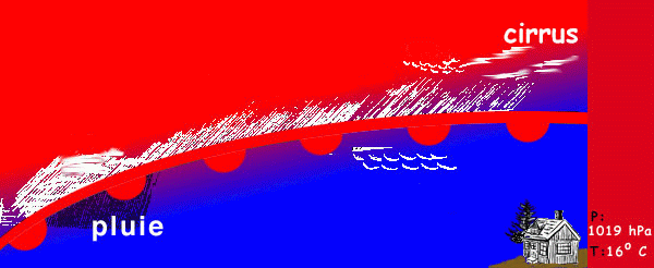
Cold Front Click here to see an animation of the advanced cold frontWARM FRONT There is formation of a warm front when a mass of warm air moving forward to a cold air mass. As the front approaches the atmospheric pressure decreases slightly, the temperature increases and the wind changes direction. In the sky will be observed, in order : cirrus, cirrocumulus, cirrostratus and/or altocumulus, altostratus and finally a nimbostratus with rainfall. Then, when the warm front is passed it is possible to see stratus. According season, the precipitations will be either rain or drizzle or hail or the sleet or snow. Precipitations last longer than those of the cold front as they can be extended until 48 hours after the passage of the warm front. Area precipitations can make between 250 and 300 km long. Warm fronts move only 12,42 mph (20 km/h).
warm front Click here to see an animation of advanced warm front OCCLUDED FRONT An occluded front is created when a cold front, faster joins a warm front in the circulation of the disturbance. The more dense cold air mass lifts the lighter warm air mass that eventually no longer be in contact with the ground. It occurs when regular rainfall and can be significant. The arrival of an occluded front is marked by a decrease in atmospheric pressure and a large nebulosity accented by cumulus " fractus " at low altitude. There are 2 types of occluded front : - The case of occlusion to hot character, cumulonimbus remain isolated.
The cup of warm occluded front -
The cup of cold occluded front WARNING
|


