Atmosphere
 Atmos. turbulences
 Ocean and climate
 Natural Factors
 Climatic and oceanic phenomenas
 Photos, videos
 Diverse
 Simulations...
THE
COMPOSITION OF TROPOSPHERE The troposphere is the densest of the four layers of the atmosphere and contains up to 75% of the mass of the atmosphere. It consists mainly of nitrogen (78%) and oxygen (21%) with only small concentrations of other gases. Almost all atmospheric water vapor or humidity is in the troposphere. The troposphere is overcast by the tropopause, a region where the temperature is stable. The air temperature begins to rise into the stratosphere. Such a temperature increasing prevents much air convection beyond the tropopause, and therefore most weather phenomena, including bearing clouds of thunderstorms, cumulonimbus, are confined to the troposphere. This is the most troubled layer, constantly shook by vertical and horizontal movements. The vertical turbulence is due to the vicinity of the Earth's surface, which determines by on the one hand mechanical ascents (rubbing) and on the other hand thermic ascents (by thermoconvection and instability). The circulation of the atmosphere depends on cosmic factors (solar radiation), global (state of the atmosphere, Earth's rotation around its axis, ocean salinity and temperature), geographical (distribution of continents and seas, vegetal covers, ice cover). It results in longitudinal, latitudinal, rising and decreasing movements.
This chart is produced and update with
data of the Air is a gas which has weight. The atmospheric pressure is the weight of a column of air extending from a given altitude to the top of the atmosphere and this weight is applied to all objects on the surface of the Earth. It measures with a barometer by counterbalancing the weight of air with mercury. This method became so widespread that often the height of a column of mercury expresses the pressure. So the pressure can be measured in millimeters or inches of mercury, or in kilopascals (kPa) or hectopascal (hPa) or millibars (mb). At sea level, the pressure is 101,32 kPa or 1013,20 hPa or mb. When the pressure exceeds 1013 hPa this corresponds to an anticyclone but when the pressure is less than 1013 hPa is a depression and the lower it is more is windy. An increase of air pressure generally favors the good weather while falling pressure is often associated with bad weather and if it goes down very quickly or 4 hPa or more in the last 6 hours, a storm and even thunderstorms approaches. In France : In the world : The atmospheric pressure is an essential element for weather forcast, even if atmospherical pressure forcasts weather at 80%, it remains 20% spent on other elements of meteorology.
A video explanation of atmospheric pressure According the Buys Ballots rule surface winds do not blow
exactly from anticyclones to depressions. The
Coriolis force deflects the wind from their theoretical
trajectory to the right in the Northern Hemisphere and to
the left in the Southern Hemisphere. This deviation is null
at the equator and maximum at the poles.
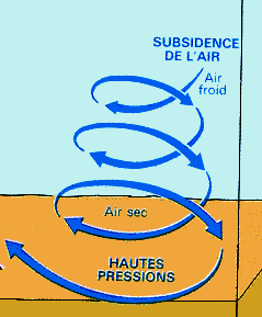
The air leaves the anticyclone (A) by
turning in the direction The rising air cools, indeed, by adiabatic expansion, and the opposite characterizes the descending air. The more air hot the more air is light and vice versa.
Click here to see an animation of a cold front into a warm front
Animation of atmospheric circulation
in 3D:
WARNING
|
.gif)