The Jet Stream is a very fast stream of air a few
hundred kilometers wide, and only a few kilometers thick.
It is usually located at the tropopause between 6-9
miles (10-15 kilometers) above the Earth's surface.
These currents blowing from west to east according to
the rotation of the Earth. Winds speed inside these
currents is about 124 to 186 mph (200 to 300 km/h) but
can exceed 248 mph (400 km/h).
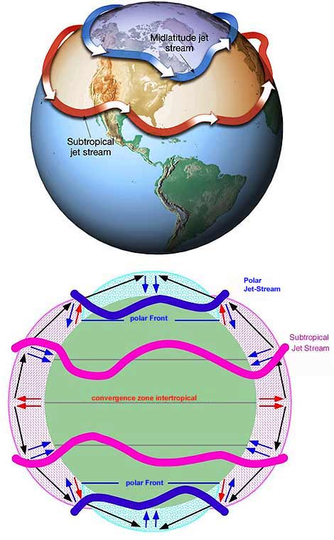
There are two main jet streams :
- the subtropical jet stream at about 30 degrees
latitude ;
- the polar jet stream at about 60 degrees latitude.
A jet stream is formed when a warm current from the tropics
meets a cold current from the poles. The strong thermal contrast
forces the air to flow horizontally and as the Earth rotates,
this fast-moving air picks up speed and produces a jet stream.
The location of the jet stream denotes the place of the
strongest contrasts of temperatures between different latitudes
on the Earth's surface, thus sharing, or bounding, the cold
air (north) of hot air (south) of jet stream in the Northern
Hemisphere. For example, when the winter is mild in southern
Quebec, it is because the jet stream retreats northward in
Canada, so it is not uncommon, during a severe winter of see
the jet stream plunging down on the Gulf of Mexico and bringing
cold air into the center of the United States. Often, even
within the jet stream, there are areas where the wind is stronger
than around. These regions play an important role in the formation
of precipitation and depressions. Moreover, we note that systems
tend to borrow their trajectory. The jet stream can take directions
towards the north according to the movement of air masses.
Consequently, the strongest jet streams usually occur during
the winter months, when large differences of temperature exist
between low and high latitudes. During El Niño,
events, the jet streams are increasing, because the rise of
temperature in the central Pacific increases the difference
of pressure between the equator and mid latitudes. The
NAO has the same effect, but much smaller. When the NAO+
jet stream is more located to the north than in the NAO-.
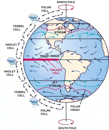
The subtropical jet streams that
circulate in parallel with latitudes (green
arrows) furnish the trade winds, returning
toward the equator (blue arrows),
completing the Hadley cell. They also feed the winds that
are moving towards
the poles and are part of the Ferrel cell. Global atmospheric
circulation includes several "cells" or loops
juxtaposed
wind. In an event El
Niño, which modifies the Walker cell (parallel
to the equator) and the Hadley cell, neighboring
cells are also modified, as well as their neighbors ...
which is why El Niño has implications across the
globe.
WARNING Patricia
Régnier helped me correct mistakes, please
you to visit her
blog
I’m not english speaker, some improprieties can
appear to english masters.
Could you help me reporting by mail any fault you
read. Thank you for all.
Contact :
 Atmosphere
 Atmos. turbulences
 Ocean and climate
 Natural Factors
 Climatic and oceanic phenomenas
 Photos, videos
 Diverse
 Simulations...