 Atmosphere
 Atmos. turbulences
 Ocean and climate
 Natural Factors
 Climatic and oceanic phenomenas
 Photos, videos
 Diverse
 Simulations...
|
3st
PART
CONSEQUENCES OF STORMS Storms are after floods climate phenomenon that cause the most of damage. They can have a significant impact for both the man or his activities and the environment (trees fall on forests, habitat damages, ports...). The number of victims may be more or less important depending on the extent and power of the storm. The consequences of storms are mainly economic. That means costs and losses or disruption to activities resulting from damage or destruction (private or public buildings, industrial or transport infrastructures, etc).
Both storms on December 1999 caused
in France STORMS OF 1999 IN FRANCE 26 and 27/12/1999 France and neighboring
countries have experienced one of the worst storms of the
century. There were 88 deaths in France and about ten in Switzerland,
Germany, Spain, Great Britain ..., 3.50 million homes without
electricity or heating, hundreds of cars damaged by falling
trees, tens of thousands of uprooted trees, more than 12 billion
euros of damage and about 500,000
hectares of forest. Such events would occur about once every
hundred years.
The second storm passed more southern circulating
at the Loire with a pressure of 965 hPa and wind gusts up
to 184 km/h in Ouessant Island, 173 km/h in Ile-de -France,
and even more than 200 km/h on the Ile de Ré. It crossed
the France moving at a speed close to 100 km/h. at about 19
pm local time it was over Nantes then at about 22 hours local
time in Romorantin and the 12/28/1999 at 1:00 over Dijon in
the morning.
The map atmospheric pressures recorded during the second storm
A video showing the power of the storm
of 1999
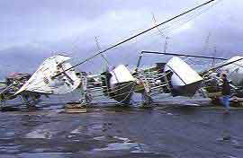
The damage from these storms
Spilled boats by the storm of December 1999
A pine forest ravaged by the storm of December 1999 THE STORM OF 2010 (Xynthia) On the night of Saturday 27 to 28/02/2010 one of the most violent storm coming from the west of Portugal reached the France with 53 casualties and damage costing about € 1 billion, uprooting many trees,. winds of more 150.km/h were recorded in Charente-Maritime or even 200.km/h in the Pyrenees (over 237.km/h on the Pic du Midi at 2877 km of altitude) causing damage to ski resorts. In the spanish Basque Country some weather stations have recorded gusts 228.km/h in Roduna, 176.km/h in Cerroja... Between
:
Here are 2 photos taken by photographer
Philippe Cherel The violence of this storm of unusual intensity at the end of winter is explained as those of 1999 by the presence much further south than usual a cold current at high altitude (jet stream), with westerly winds fast and very strong, and a warm air mass in low layer, around 1500 meters above the ground.
WARNING
|


)