Atmosphere
 Atmos. turbulences
 Ocean and climate
 Natural Factors
 Climatic and oceanic phenomenas
 Photos, videos
 Diverse
 Simulations...
|
2st
PART
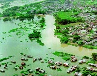
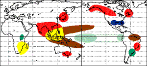
- CONSEQUENCES OF EL NINOWhen this phenomenon occurs, many countries are affected. Waters are less warm in Indonesia and anticyclones are created instead of the depressions. Which causes droughts in Australia and Indonesia, see also forest fires in areas that usually have abundant rainfall. But there are fewer hurricanes in the Western Pacific. These waters which are brought across the Pacific cause a decrease of atmospheric pressure so an increase of precipitation on the East coast of South America (especially northern Brazil, the Peru) : see major flooding in usually desert areas.
In December 1997 and January 1998 during
the "El Niño", Hurricanes affecting Polynesia are on the increase well as number tornadoes, causing dramatic consequences. The water it warms up it intersects upwelling (ascent) of cold water and nutrient-rich foods, and many kinds of fishes migrate towards the Pole, severely reducing the population in this part of the Pacific Ocean. South and East Africa, South India, and Pakistan are also experiencing droughts and the floods in India are sporadic. In the Atlantic ocean the number of hurricanes decreased during the El Niño phenomenon.
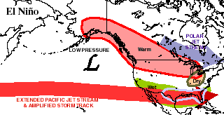
During El Niño events, jet streams
are intensifying because the rise in the Click here to see the effect of El Nino on the Jet Stream
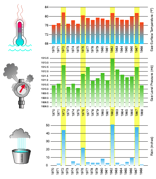
As you can see, during the years of
El Niño(highlighted
in yellow) the
Click
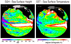
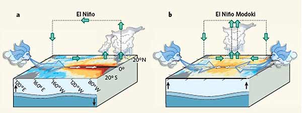
here to see the simulation of rainfall anomalies caused by Click here for the forecast of El Niño or La Niña (source N.O.A.A.) Since 2007 a new type of El Niño was found from the analysis of a Japanese group who named it warm pool El Niño or El Nino Modoki in Japanese. This El Niño is distinguished from its cousin by its specific impact on global atmospheric circulation.. Traditionally, the classic El Niño is associated with warming in the East tropical Pacific (Niño 1+2 et 3). However, during the El Niño Modoki sea surface temperature (SST) anomaly in East Pacific is not affected by a warming but rather by cooling just like the western equatorial Pacific, while a warm anomaly affects the central equatorial Pacific (Niño 3.4). These zonal gradients of SST translat into anomaly of two cells of the Walker Circulation on the tropical Pacific, with a humid region in the central Pacific. The thermocline doesn't tilt in the same way because during El Niño classic it rise up in West equatorial Pacific for descend in Eastern Pacific while during his cousin the thermocline rises at each end of the equatorial Pacific Ocean and sinks in the center of the Pacific.
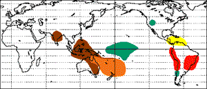
During classic El Niño West Coast of the United States is humid but during El Niño Modoki is rather dry. While during the classic El Niño there is a significant reduction of precipitation over the north and south of Australia, but Modoki event appears to result in a large-scale reduction in rainfall in the North West and Northern Australia. India is also affected by droughts with this second type of El Niño unlike classic phenomenon has long been known.
WARNING
|
|||||||||||||||||||||||||||||||||||